Evago

Cancun / Mexico Things to do

What are the most worthwhile things to do in Cancun on a first visit?

The short answer

The El Rey archaeological zone and the federal marine park offshore — a Maya trading port open daily 8:00 to 17:00 for 75 pesos, and 8,673 hectares of protected reef, seagrass and sand that governs almost every boat trip you can book.
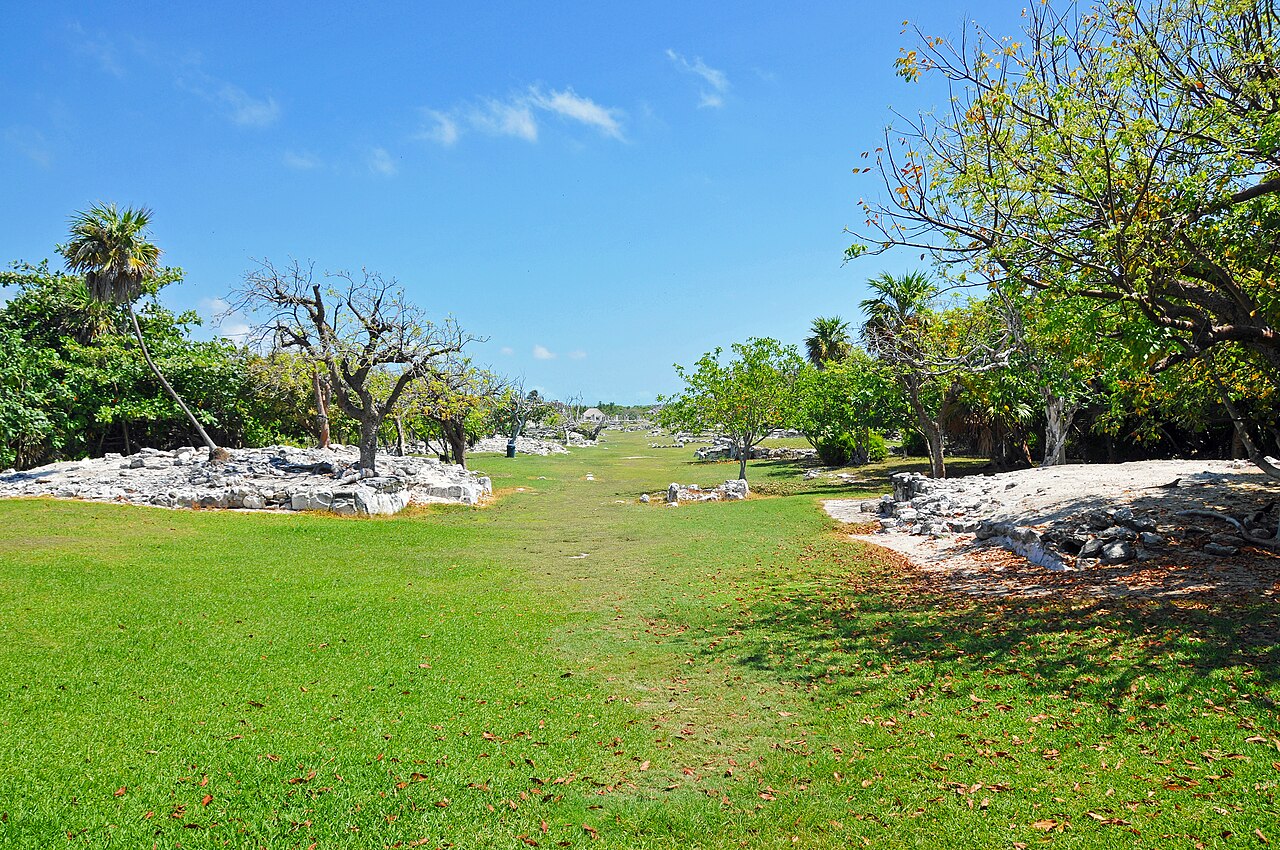
El-Rey, is in the middle of Cancun Island, literally right in the middle of the most popular resort area in Mexico. Most people are not aware of this site and it is not easy to find the entrance. Archaeologists estimate that habitation at El Rey by the ancient Maya occurred approximately in 900 AD and continued in part until 1550 AD, ending at the start of the Spanish Conquest. El Rey is translated from Spanish to the "The King" and was named for a ceremonial mask , a sculpture of a nobleman and a skull found on the site that honors the Maya Sun God. The sites ancient name is unknown and is still open to speculation and interpretation. There is known to be at least 47 Maya structures on site with most being minor in design and recognition. The two primary platforms and temples still evident are believed to be the remains of religious ceremonial buildings and market areas. Overall, the site is currently considered minor in relative importance and size to the other Maya Ruins sites in the region such as Chichen Itza, Uxmal, Coba and Tulum but does give visitors the opportunity to experience the Maya of the past without leaving Cancun.
This file is licensed under the Creative Commons Attribution-Share Alike 2.0 Generic license. You are free: to share – to copy, distribute and transmit the work to remix – to adapt the work Under the following conditions: attribution – You must give appropriate credit, provide a link to the license, and indicate if changes were made. You may do so in any reasonable manner, but not in any way that suggests the licensor endorses you or your use. share alike – If you remix, transform, or build upon the material, you must distribute your contributions under the same or compatible license as the original.https://creativecommons.org/licenses/by-sa/2.0CC BY-SA 2.0 Creative Commons Attribution-Share Alike 2.0 truetrue Author .mw-parser-output .commons-creator-table{background-color:#f0f0ff;box-sizing:border-box;font-size:95%;text-align:start;color:inherit}.mw-parser-output .commons-creator-table>tbody>tr{vertical-align:top}.mw-parser-output .commons-creator-table>tbody>tr>th{background-color:var(--background-color-neutral,#e0e0ee);font-weight:bold;text-align:start;color:inherit}.mw-parser-output .mw-collapsible-toggle-expanded.mw-collapsible-arrowtoggle,.mw-parser-output .mw-collapsible-toggle-expanded .mw-collapsible-arrowtoggle{padding-left:20px!important;background-image:url("https://upload.wikimedia.org/wikipedia/commons/1/10/MediaWiki_Vector_skin_action_arrow.png");background-repeat:no-repeat;background-position:left center}.mw-parser-output .mw-collapsible-toggle-collapsed.mw-collapsible-arrowtoggle,.mw-parser-output .mw-collapsible-toggle-collapsed .mw-collapsible-arrowtoggle{padding-left:20px!important;background-repeat:no-repeat}.mw-parser-output .commons-creator-table[dir="ltr"] .mw-collapsible-toggle-collapsed.mw-collapsible-arrowtoggle,.mw-parser-output .commons-creator-table[dir="ltr"] .mw-collapsible-toggle-collapsed .mw-collapsible-arrowtoggle{background-image:url("https://upload.wikimedia.org/wikipedia/commons/4/41/MediaWiki_Vector_skin_right_arrow.png");background-position:left center}.mw-parser-output .commons-creator-table[dir="rtl"] .mw-collapsible-toggle-collapsed.mw-collapsible-arrowtoggle,.mw-parser-output .commons-creator-table[dir="rtl"] .mw-collapsible-toggle-collapsed .mw-collapsible-arrowtoggle{background-image:url("https://upload.wikimedia.org/wikipedia/commons/1/1e/MediaWiki_Vector_skin_left_arrow.png");background-position:right center}@media(max-width:719px){.mw-parser-output .commons-creator-table,.mw-parser-output .commons-creator-table>tbody{box-sizing:border-box;display:block;width:100%}.mw-parser-output .commons-creator-table>tbody{border-right:1px solid var(--border-color-base,#aaa);border-bottom:1px solid var(--border-color-base,#aaa)}.mw-parser-output .commons-creator-table>tbody>tr{border-top:1px solid var(--border-color-base,#aaa);display:flex;flex-wrap:wrap}.mw-parser-output .commons-creator-table>tbody>tr>th{border-left:1px solid var(--border-color-base,#aaa);padding:2px;flex:1 1 100%}.mw-parser-output .commons-creator-table>tbody>tr>td{border-left:1px solid var(--border-color-base,#aaa);padding:2px;flex:1 1}}@media(min-width:720px){.mw-parser-output .commons-creator-table{border:1px solid var(--border-color-base,#aaa);border-collapse:collapse;border-spacing:0;padding:5px}.mw-parser-output .commons-creator-table>tbody>tr>th,.mw-parser-output .commons-creator-table>tbody>tr>td{border:1px solid var(--border-color-base,#aaa);padding:2px}.mw-parser-output .commons-creator-table>tbody>tr>.halfwidth{max-width:10em}.mw-parser-output .commons-creator-table>tbody>tr>.fullwidth{max-width:20em}}@media screen{html.skin-theme-clientpref-night .mw-parser-output .commons-creator-table{background-color:#0c0b19}}@media screen and (prefers-color-scheme:dark){html.skin-theme-clientpref-os .mw-parser-output .commons-creator-table{background-color:#0c0b19}} Dennis G. Jarvis Alternative names pseudonym: archer10; Archer10 Description photographer Authority file : Q122977591 creator QS:P170,Q122977591 .mw-parser-output .note{background-position:left 7px top 50%;padding:0.5em 0.5em 0.5em 40px;margin:0.5em 0;overflow:hidden;background-color:var(--background-color-base,#fff);color:var(--color-base,#202122);background-repeat:no-repeat;border:1px solid var(--border-color-base,#ddd)}.mw-parser-output .note-inline{display:inline-block;vertical-align:middle}.mw-parser-output .note-info{background-color:var(--background-color-base,#fff);color:var(--color-base,#202122);background-image:url("https://upload.wikimedia.org/wikipedia/commons/e/ec/OOjs_UI_icon_information-progressive.svg");background-size:25px;border:1px solid var(--border-color-progressive,#6485d1);padding-left:40px;min-height:25px}.mw-parser-output .note-reminder{background-color:var(--background-color-warning-subtle,#fdf2d5);color:var(--color-base,#202122);background-image:url("https://upload.wikimedia.org/wikipedia/commons/a/a8/OOjs_UI_icon_lightbulb-yellow.svg");background-size:25px;border:1px solid var(--border-color-content-removed,#ffe49c);min-height:25px}.mw-parser-output .note-warn{background-color:var(--background-color-warning-subtle,#fdf2d5);color:var(--color-base,#202122);background-image:url("https://upload.wikimedia.org/wikipedia/commons/3/3b/OOjs_UI_icon_alert-warning.svg");background-size:25px;border:1px solid var(--border-color-content-removed,#ffe49c);min-height:25px}.mw-parser-output .note-error{background-color:var(--background-color-error-subtle,#ffe9e5);color:var(--color-base,#202122);background-image:url("https://upload.wikimedia.org/wikipedia/commons/b/bf/OOjs_UI_icon_notice-destructive.svg");background-size:25px;border:1px solid var(--border-color-destructive,#f54739);min-height:25px}Please see the license conditions. Also, if used outside WMF projects, the photographer would appreciate if you'd let them know · CC BY-SA 2.0 File source

The answer, with local context

El Rey is in the hotel zone, not a day trip away from it: kilometer 18 of Boulevard Kukulcán, on the southern half of the sand bar, between the Caribbean Sea and the Nichupté lagoon. Admission is 75 pesos. It opens every day from 8:00 to 17:00 with last entry at 16:30. The occupation runs deep — the earliest finds date to roughly 300 CE, when a small fishing community lived there in wooden, palm-roofed houses, and the site became significant between 1300 and 1550 as a port on the Caribbean coastal trade route. Its main avenue runs north to south, lined with residential platforms and small square altars, masonry buildings to the south and platform foundations to the north; some structures still carry fragments of painted murals of gods. After the Spanish arrival the residents left for the interior and the island stayed uninhabited until the early twentieth century. The site takes its name from an anthropomorphic sculpture believed to depict a noble figure.

The water is the other half of a first visit, and it is regulated. The Parque Nacional Costa Occidental de Isla Mujeres, Punta Cancún y Punta Nizuc covers 8,673 hectares off the Isla Mujeres and Benito Juárez municipalities. It was created as a marine national park by presidential decree published on 19 July 1996 and later reclassified as a national park. Its management program divides it into named subzones with different rules: 6,031 hectares of public-use seagrass and sand flats, 1,219 hectares of public-use reef, 436 hectares of restricted reef preservation, 968 hectares of sustainable-use commercial fishing, and 18 hectares set aside for the recovery of reef and benthic species.

Those subzone boundaries determine where a boat can take you. In the restricted preservation subzone, diving of every kind is prohibited — scuba, freediving, night diving, semi-autonomous and snuba — along with anchoring that damages reef, feeding or harassing marine life, extracting flora or fauna, touching or standing on reef, and navigating over reef formations. Vessels drawing more than 2.0 meters are barred from it outright.

Picture the place

Cancún's geography is unusual and it shapes everything: a narrow barrier of sand with the open Caribbean on one side and the Nichupté lagoon on the other, with a Maya port site sitting between the two at kilometer 18. The reef formations the park protects lie close enough inshore that the protected zoning sits directly in front of the hotels rather than somewhere out of sight.

The easily missed detail

The park's management program sets a hard global ceiling on motorized vessel use: 613 authorized vessels and 6,106 passenger seats, based on 2015 figures. That is a fixed cap on how many people can be on the water in the park at once, which explains why reef trips in high season are not simply busy but genuinely finite. It also means a trip sold as going to "the reef" may be heading to the public-use reef subzone rather than anywhere the preservation rules exclude.

A practical rhythm

  • Morning — El Rey at opening, 8:00, before the exposed coastal platforms heat up. Last entry is 16:30, so an afternoon arrival is tight.
  • Midday — The public-use subzones, 6,031 hectares of seagrass and sand plus 1,219 hectares of reef, are where licensed boat activity is concentrated.
  • Any day — Check which subzone a reef trip actually enters. The 436-hectare preservation subzone allows no diving of any kind.

What could complicate the plan

Capacity, not availability, is the limiting factor on the water: 613 vessels and 6,106 seats is the park-wide maximum. El Rey's 16:30 last entry closes the day earlier than the 17:00 posted closing time suggests. Nothing in the park permits touching or standing on reef, and a tour that offers it is offering something prohibited. The US Department of State's Mexico advisory of 29 May 2026 sits at Level 2 — Exercise Increased Caution — nationwide, with separate assessments by state inside it.

What to do next

The when-to-visit question in this group explains how the Atlantic hurricane season overlaps the months when these reef capacity caps bite hardest.

Sources

  1. Instituto Nacional de Antropología e Historia — El Rey hours, 16:30 last entry, 75-peso admission, occupation dates, site layout and location
  2. Diario Oficial de la Federación — park name, 8,673-hectare area, 19 July 1996 decree, subzone areas, prohibited activities, 2.0 m draft limit, 613-vessel and 6,106-seat caps
  3. US Department of State — Mexico advisory level and date

All questions about Cancun / Mexico