Bahamas country guide Places and experiences
What should a first-time traveler see in Bahamas beyond the obvious highlights?
The short answer
Go where the protection is, not where the resorts are — the Bahamas National Trust holds the Exuma Cays Land and Sea Park under a statutory mandate dating to The Bahamas National Trust Act of 1959, and the parks it manages are the clearest route into the archipelago's non-resort geography.
The answer, with local context
Scale is the first thing to fix. The Government of The Bahamas counts 700 islands and 2,400 cays strung across roughly 760 miles between Florida and Haiti, with only 30 of them inhabited and a total land area of 5,358 square miles, or 13,878 square kilometers. Against that, the Bahamas National Trust manages 33 national parks covering more than 2.2 million acres of land and sea, and throws them open free for one day a year — National Parks Day, held on 26 April in 2025 in its seventh year. Those two sets of numbers together set the shape of a first trip past the resorts: the protected estate is enormous, mostly marine, and reachable only in pieces.
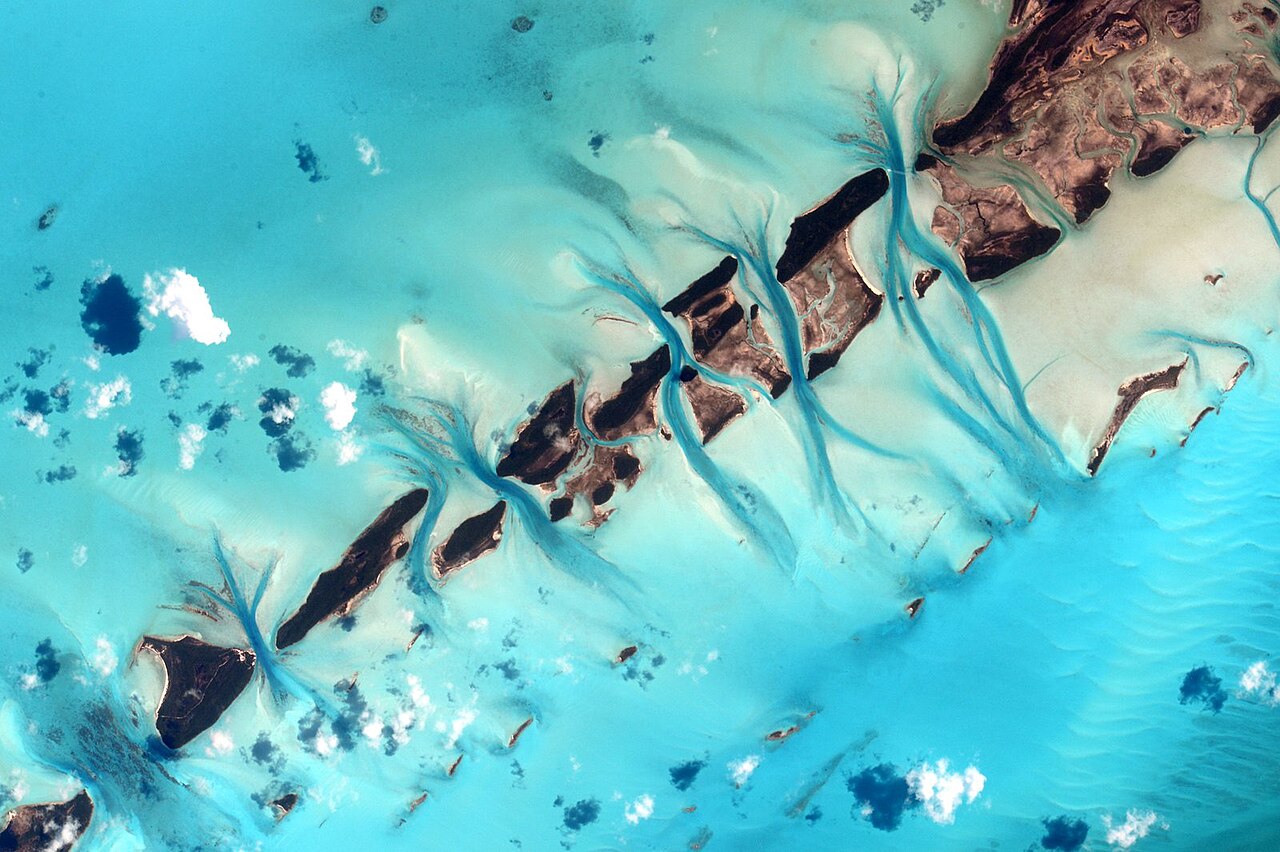
The Bahamas is read by most visitors as one or two islands with airports attached, which badly undersells a country spread across hundreds of miles of shallow bank and deep channel. The Exuma chain alone extends far enough that the park covering part of it takes in 176 square miles, and its headquarters at Warderick Wells Cay is reached by boat rather than road. The archipelago's shape — long, narrow banks cut by tidal channels — is the thing a first-time visitor should try to see, and it is visible from the water and the air in a way it is not from a beach.
Wildlife is the second argument for going beyond the obvious. The park protects the Bahamian hutia, an endemic and endangered rodent, along with rock iguanas, sea turtles, nesting seabirds and Caribbean reef sharks. Specific sites within it have specific draws: the Rocky Dundas Caves have two entrances with underwater passages at high tide; Danger Reef holds Caribbean reef sharks at depths of 25 to 30 feet; a plane has been sunk to about 15 feet to form an artificial reef. Shroud Cay's mangrove creeks can be explored by dinghy, kayak or paddleboard, and Warderick Wells has nature trails, a sandbar, Boo Boo Hill and the ruins of the Davis family plantation.
The waters around all of this are now part of a wider conservation story. NOAA Fisheries, in listing the queen conch as threatened under the Endangered Species Act, found that critical habitat for the species was not yet determinable and that any designation would follow in a separate future rulemaking — which is a useful reminder that the Bahamian shallows are still being mapped for protection rather than finished.
Picture the place
Seen from above, the banks read as a system of pale fans and dark channels — tidal flats that go almost white at low water, cut by deeper lines where the current runs. From sea level the same geography appears only as a color change, which is why the archipelago makes more sense from the air than from a lounger. NASA's astronaut-photography record of Little Bahama Bank, shot on 20 October 2016 during Expedition 49 with a 1,150 mm lens, uses Strangers Cay — 3.6 kilometers, or 2.25 miles, end to end — as the ruler for how large those sand bodies run.
The easily missed detail
The park's most important function is not recreational. The Bahamas National Trust describes it as a fisheries replenishment area for fish, conch and lobster across the Exumas and surrounding waters — meaning the closed area is what keeps the open areas productive. Commercial or documentary filming and research inside it require a Trust permit, and aircraft and helicopter use is decided case by case.
A practical rhythm
- Shroud Cay — Take the mangrove creeks by kayak or paddleboard, keeping to the north creek's idle-speed rule.
- Warderick Wells — Walk the marked trails, which is also the park's requirement: visitors must stay on them.
- O'Briens and Cambridge — Snorkel the southern end of the park, where Cambridge Cay anchors the southern mooring area.
What could complicate the plan
Everything inside the park is boat-access, and the rules are enforced rather than advisory. Pets are allowed on beaches only, leashed to no more than six feet, and are barred from trails and brush. Poaching can be reported anonymously on VHF channel 9. For a traveler without a vessel, reaching the park at all means arranging a charter from Great Exuma or Nassau, and that logistics step — not the park's rules — is what most often keeps first-timers on the resort islands.
What to do next
The Bahamas food question explains the closed seasons and size limits that govern what comes out of these same waters, and the when-to-visit question covers the storm season that determines when you can get out there.
Sources
- Bahamas National Trust, Exuma Cays Land and Sea Park quick guide — park area and headquarters, species including the Bahamian hutia, Rocky Dundas Caves, Danger Reef, airplane wreck, Shroud Cay creeks, Warderick Wells features, replenishment-area role, filming and research permits, trail and pet rules, poaching reporting
- NASA, International Space Station Expedition 44 imagery — tidal flats and channels of the Bahamas photographed from orbit
- NASA Earth Observations, Little Bahama Bank — the Expedition 49 photograph of 20 October 2016, the 1,150 mm lens and the length of Strangers Cay
- Government of The Bahamas, overview of The Bahamas — island and cay counts, inhabited islands, land area and the archipelago's extent
- Bahamas National Trust, National Parks Day 2025 — 33 national parks, more than 2.2 million acres of land and sea, and the free-entry date
- NOAA Fisheries, final rule listing queen conch as threatened under the Endangered Species Act — critical habitat not yet determinable and deferred to future rulemaking