Belize country guide Places and experiences
What should a first-time traveler see in Belize beyond the obvious highlights?
The short answer
Toledo in the far south and the Mountain Pine Ridge highlands — the two parts of Belize that look and feel least like the cayes, and where the country's own weather records show it is a genuinely different place.
The answer, with local context
Belize is usually sold as a reef. Its interior is a different country. The National Meteorological Service's station at Cooma Cairn, in the Mountain Pine Ridge at 952 meters, records an annual average maximum of 77.5°F (25.3°C) and an average minimum of 63.8°F (17.7°C) — against 86.2°F (30.1°C) and 72.6°F (22.6°C) at Philip Goldson International Airport on the coast. Pine ridge, granite, waterfalls and cool nights are not what the brochures lead with, and they are an hour or two from Cayo's main road.
Toledo, the southernmost district, is the wet extreme. Mean annual rainfall in the south reaches 160 inches (4,064 mm) against 60 inches (1,524 mm) in the north, and the rains begin there in early May, a full month before they reach Corozal in the far north. Toledo is also the only part of the country where the "Mauga" dip in August rainfall — a real feature of the national pattern — does not show up. The consequence on the ground is rainforest rather than scrub, cacao rather than cane, and the fewest visitors of any district.
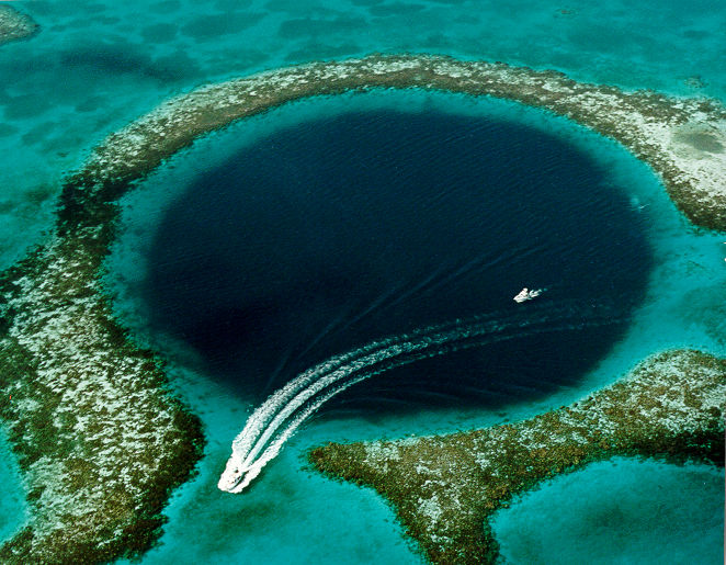
Offshore, the parts of the World Heritage property that almost nobody reaches are worth naming. The Belize Barrier Reef Reserve System has seven components, and the three least visited are Bacalar Chico National Park and Marine Reserve in the north, Sapodilla Cayes Marine Reserve in the far south, and Laughing Bird Caye National Park off the Placencia peninsula. Half Moon Caye Natural Monument, on Lighthouse Reef, is the other overlooked one — the same atoll as the Blue Hole, which takes all of the attention. Together the seven reserves cover about 12% of the reef complex, which means most of the reef is not inside the property at all.
Picture the place
The Mountain Pine Ridge is open Caribbean pine over coarse granite soil, red-orange tracks and a thin, resinous smell — the landscape of a temperate upland dropped into the tropics. Toledo is the opposite: closed-canopy broadleaf forest where the rivers run brown after rain and the limestone underneath has been eaten into caves.
The easily missed detail
Belize's World Heritage listing is marine. The property UNESCO inscribed in 1996 under criteria (vii), (ix) and (x) is the reef system — the inland Maya cities, remarkable as they are, do not carry that designation. Travelers who use the World Heritage list as a trip filter will therefore miss the entire interior, and will also miss that the reef property's own component reserves run from the Mexican border to the Guatemalan one, giving the country a second, longer axis than the Ambergris-and-Caulker one most itineraries use.
A practical rhythm
- First days — Cayo and the Mountain Pine Ridge, where the 952-meter station records nights nearly 9°F cooler than the coast.
- Middle — South along the coast to Stann Creek and the Garifuna towns, where the rains arrive in late May rather than early May.
- Last days — Toledo, the wettest and least-traveled district, or a boat to Sapodilla Cayes from the far south.
What could complicate the plan
Overland distances are short but slow, and almost every route touches Belize City, which the US Department of State rates Level 3, Reconsider Travel, within an overall Level 2 advisory for the country reissued on December 30, 2024; the advisory names the area south of Haulover Creek Canal extending to Fabers Road as the focus of gang-related violence and advises avoiding the city. UK passport holders get 30 days visa-free and pay 200 Belize dollars for each additional 30 days through the Belize Immigration and Nationality Department, which caps how slowly you can travel. In the south, roads and river crossings are least reliable once the rains arrive in early May.
What to do next
The when-to-visit answer in this group sets the seasonal window and explains which reef component to aim for; the food answer follows the same north-to-south geography through the kitchen.
Sources
- National Meteorological Service of Belize, climate summary — Cooma Cairn and airport station averages, rainfall range, onset of rains by district, the August "Mauga" dip
- UNESCO World Heritage Centre, Belize Barrier Reef Reserve System — inscription year and criteria, the seven component reserves, share of the reef complex
- US Department of State, Belize travel advisory — advisory levels, reissue date, named area of concern
- UK Foreign, Commonwealth & Development Office, Belize entry requirements — visa-free period and extension fee