Kiribati country guide When to visit
When is the best time to visit Kiribati for Tarawa?
The short answer
July — the heart of the dry trade-wind season (May–October) and the month of Independence (July 12, 1979), when Tarawa's maneabas fill with a week of dance competitions, feasts and national celebrations in the year's most reliable weather.
The answer, with local context
Kiribati's climate calendar is a wind calendar, and the Kiribati Meteorological Service's seasonal record is the authority: the wet season runs November to April under westerly winds (squalls, heavy showers, Tarawa's monthly rain up toward 8 inches), and the dry season runs May to October under the southeast trades — breezier, sunnier, monthly rain down near 2–3 inches, and the same relentless equatorial warmth (daytime highs sit near 88°F / 31°C all year; the seasons are about water, not temperature). July is the dry season's core on both counts: the trades are at their steadiest, lagoon crossings to the outer islands run most reliably, and snorkelling and Battle-of-Tarawa wreck sites sit in their clearest water. Overlay the civic calendar and the choice locks: Independence Day (July 12) anchors a celebration week in the capital — maneaba dance competitions, choir festivals, canoe racing and feasting — the single week when Tarawa performs itself at full strength.
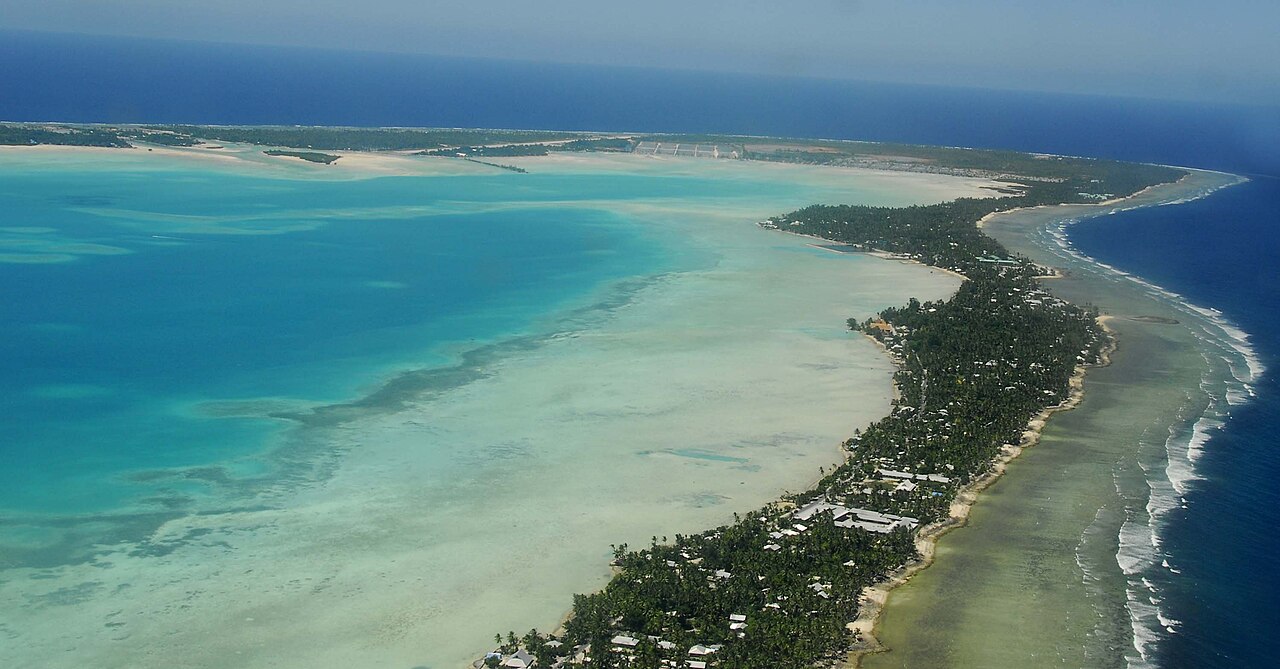
The anchor itself deserves its scale stated, because Tarawa is unlike any other Pacific capital: it is not a town but a ribbon. South Tarawa is a chain of islets linked by causeways, Betio at the west end to Tanaea at the east, some 30 km of single road with lagoon on 1 side, ocean on the other, and over half the nation's people — the 2020 census counted 119,438 i-Kiribati in total, more than 60,000 of them on this strip alone. The nation's facts frame any visit: 33 islands (32 low atolls plus the raised island of Banaba) scattered over about 3.5 million km² of Pacific — the only country on Earth lying in all 4 hemispheres — with a total land area of 811 km². Entry is genuinely simple: under Kiribati's Entry and Visa Exemption Order (2023), U.S. citizens (and most other visitors) enter visa-free for up to 1 month per visit (a maximum of 90 days in any 12-month period), with a passport valid 6 months, an onward ticket and proof of funds — the U.S. Department of State's Kiribati page confirms the paperwork trio.
What fills a July week on the ribbon: Betio, the western islet, holds the Pacific war's relics in situ — the Battle of Tarawa (November 20–23, 1943) left Sherman tanks standing in the lagoon at low tide, Japanese coastal guns, bunkers and the memorials of Red Beach along a shore now dense with villages; the cultural museum Te Umanibong at Bikenibeu holds the maneaba culture in objects; and North Tarawa, the thin green chain across the lagoon (reached by causeway to Buota, then boat), is the capital's quiet mirror — villages, swimming beaches and homestays a world away in feel from the Betio end. The dry season's other months are all workable (June through September is the sweet band), but July alone pairs the weather with the nation's birthday — and in a country whose climate headlines are existential (average elevation barely 2–3 m; king tides flooding South Tarawa roads in the January–March perigean season), the dry-trade months are also when the atolls show their kindest face.
Picture the place
Betio at low tide: 2 rusting Sherman tanks standing hub-deep in the lagoon shallows, children playing football on the exposed sandflat around them, and the causeway running east into the haze.
The easily missed detail
Kiribati edits the calendar itself: in 1995 the country moved the International Date Line east around its territory so that all 33 islands share 1 day — before the change, Tarawa and Kiritimati lived 22 hours and 2 dates apart. Kiritimati, at UTC+14, is consequently among the first inhabited places on Earth to see each new day (Caroline Island, renamed Millennium Island, is the country's easternmost land and its sunrise marker). The twin quirk: Kiribati runs 3 time zones (UTC+12 in the Gilberts, +13 in the Phoenix group, +14 in the Line Islands), so "what time is it in Kiribati" is a question with a geography exam inside it.
A practical rhythm
- The ribbon end to end — Betio's war shore at low tide 1 day, Bikenibeu's museum and Bairiki another: the capital read slowly, village by village
- North Tarawa by boat — A crossing for the quiet side: village lunch, reef-edge swimming, back before dark
- Independence week in the maneaba — July's evenings given to the dance competitions: the country's culture, performed for itself
What could complicate the plan
Access is the first complication: Tarawa's Bonriki Airport is served from Nadi by Fiji Airways only a few times a week (plus a weekly Nauru Airlines link via Nauru), so a missed connection costs days, and all itineraries are built backwards from flight days. Then the atoll realities: Tarawa's drinking water comes from rainwater tanks and a stressed freshwater lens (drink treated or bottled water), medical care stops at Tungaru Central Hospital (serious cases are medevaced to Fiji or Australia — comprehensive insurance with evacuation cover is not optional), dengue circulates, cash in Australian dollars runs the economy (cards work at a few hotels only), and Sunday closes the country almost entirely — churches and maneabas full, shops and transport shut. ENSO bends the seasons hard: an El Niño year can drown the "dry" season, while La Niña brings the droughts that ration Tarawa's water — read the Kiribati Met Service's seasonal outlook before fixing dates.
What to do next
Fix July around the Independence week, book the Nadi–Tarawa flights first (they are the trip's skeleton), and reserve Tarawa rooms immediately after.
Sources
- Government of Kiribati — Entry and Visa Exemption Order 2023 (visa-free entry up to 1 month per visit, 90 days in any 12 months); U.S. Department of State Kiribati page (passport valid 6 months, onward ticket, proof of funds)
- Kiribati Meteorological Service (via national climate summaries) — wet season November–April, dry season May–October; Tarawa rainfall patterns
- National Statistics Office, 2020 census — population 119,438
- Kiribati National Tourism Office — Independence celebrations, the Battle of Tarawa sites and Te Umanibong museum