Micronesia country guide When to visit
When is the best time to visit Micronesia for Nan Madol?
The short answer
February — the driest, trade-wind steadiest month across all 4 states, when the boat run out to Nan Madol is calmest, Chuuk's wreck visibility peaks, and Yap's festival season approaches (Yap Day, around March 1) — in a country where even the "dry" capital island can take 300 mm of rain in a good month.
The answer, with local context
The Federated States of Micronesia is 4 nations wearing 1 flag — Yap, Chuuk, Pohnpei and Kosrae spread across some 2,700 km of the Caroline chain, 607 islands, 702 km² of land inside an EEZ of about 3 million km² — and its calendar is the trade-wind calendar, drier from roughly December to April and wetter from May to November, with typhoons spinning up in the region's waters in the wettest months. February is the overlap point where every state is simultaneously at its most workable: Kosrae's reefs at their clearest, Chuuk's lagoon visibility at its best for the Ghost Fleet, Pohnpei at its (relative) driest, and Yap warming toward Yap Day. The anchor demands the detail, though, because Pohnpei is a climate of its own: it is one of the wettest inhabited places on Earth, taking around 4,800 mm (187 inches) of rain a year at Kolonia and more in its mountainous interior (Mount Nahnalaud, 772 m, is the FSM's highest point). "Dry season" on Pohnpei is a statistical courtesy — February lowers the odds, it does not cancel the rain — and Nan Madol is best approached as a weather-window site: you go on the first calm, bright morning of your stay, and you hold alternates.
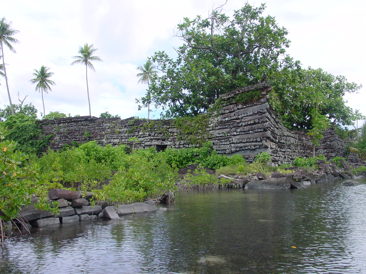
The site itself is the Pacific's great stone enigma — and UNESCO's published record is the authority this answer stands on: Nan Madol: Ceremonial Centre of Eastern Micronesia was inscribed in 2016 (criteria i, iii and vi) and placed simultaneously on the List of World Heritage in Danger, threatened by mangrove encroachment, silting canals and inadequate management. The facts behind the plaque: 92 artificial islets of coral fill faced with prismatic basalt columns, raised in the tidal lagoon off Temwen Island over an area of about 1.8 km², the ceremonial capital of the Saudeleur dynasty, which unified Pohnpei from about 1100 until its legendary overthrow around 1628. Uranium-thorium dating of coral in the royal mortuary islet of Nandauwas pins its great tomb's construction to about 1180–1200; that islet's stacked-basalt walls rise some 7–8 m, and the whole city represents roughly 750,000–950,000 tonnes of stone, quarried as far as 30 km away across the island and rafted to the reef. Some 750–1,000 people lived and worked there at the dynasty's height; it has been uninhabited since the fall, and visits run by boat from Kolonia (about 20 km away) plus a walk-in at low tide, with small fees paid to the traditional landowner and the state.
The machinery around a February trip is unusually kind to Americans: under the Compact of Free Association, U.S. citizens may enter the FSM without a visa and remain indefinitely (the State Department's Micronesia page states it plainly; a passport valid at least 180 days and the immigration and customs forms are the paperwork), while other visitors receive a 30-day entry permit on arrival. 2 time zones (UTC+10 in Yap and Chuuk, +11 in Pohnpei and Kosrae) and per-island departure taxes paid in cash are the federation's small frictions. February, then: the trades up, the lagoon glassy on the best mornings, Nan Madol's basalt black and gleaming after dawn rain, and the whole 4-state arc open in a single month — the only month of the year you can say that with a straight face.
Picture the place
Nan Madol at first light after rain: basalt log-walls rising straight from green lagoon water, a heron on the mortuary islet's wall, and not another boat on the whole reef flat.
The easily missed detail
The tide is Nan Madol's timetable: the city is threaded by canals and many islets are best reached — some only reached — by boat around higher water, while at low tide the reef flats dry and the visit becomes a wade between islets over coral and sea cucumber beds. Guides time departures from Kolonia to the tide table, not the clock, and a "9 a.m. tour" is really a "this morning's water" tour. The second detail is the fee's ownership: Nan Madol stands on land under traditional authority (the site lies within the Madolenihmw chiefdom), and the small payments to the landowner's representative at the landing are not bureaucracy — they are rent to the family whose ancestors' city this is; carry small bills and pay without bargaining.
A practical rhythm
- Nan Madol on the first fine morning — Held unbooked until the weather shows its hand, alternates stacked behind it
- Kolonia as the working base — Sokehs Ridge, the falls and the sakau bars filling the wet afternoons productively
- States sequenced west or east — February's other weeks given to Chuuk or Kosrae while the trades hold
What could complicate the plan
Pohnpei's rain is the standing complication — a February week can still deliver days of deluge (the island's rivers and waterfalls are the compensation), and Nan Madol's boat landing and islet paths go slick and submerged in bad weather. The In Danger listing is literal: mangroves are prising walls apart, canals silt, and conservation scaffolding or closed islets can alter a visit without notice. Beyond the anchor, February's promises depend on inter-island logistics: Chuuk and Pohnpei and Kosrae ride the Island Hopper (a few flights a week), Yap is not on the Hopper at all (reached by United's Guam–Yap service), and a missed connection resequences the whole federation. Health notes are standard Pacific-serious (dengue circulates; Kolonia and Weno hospitals are the ceilings of care; the outer islands have dispensaries), entry formalities include an onward ticket for non-U.S. visitors, and the per-state departure taxes are cash-only — a wad of small U.S. bills is an FSM essential, not a quirk.
What to do next
Book Pohnpei for a February week with Nan Madol uncommitted until you land, and let the first calm morning make the call.
Sources
- UNESCO World Heritage Centre — Nan Madol: Ceremonial Centre of Eastern Micronesia (inscribed 2016, criteria i, iii and vi; simultaneously listed in Danger; 92 islets, about 1.8 km²)
- U.S. Department of State — Micronesia country information (Compact entry rights: U.S. citizens may remain indefinitely without a visa; passport valid at least 180 days; per-island departure taxes)
- Archaeological literature (U-Th dating studies, McCoy et al.) — Nandauwas construction about 1180–1200; the Saudeleur era about 1100–1628
- FSM Visitors Board — state seasons, Yap Day (around March 1) and Nan Madol access and fees