Milford Sound / New Zealand Things to do
What are the most worthwhile things to do in Milford Sound on a first visit?
The short answer
Get on the water and then get under it — the fiord's walls carry on below the surface to depths of up to 265 m (869 ft), and the Piopiotahi (Milford Sound) Marine Reserve protects 690 hectares of that drowned cliff along 16 km of the northern shore.
The answer, with local context
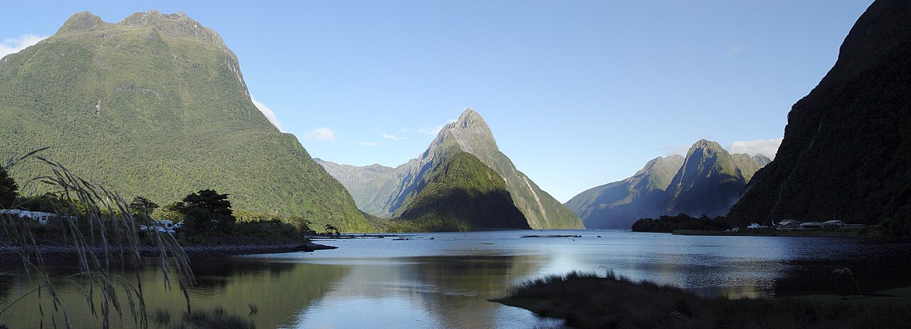
The single defining object is Mitre Peak, which DOC records rising 1,692 m (5,551 ft) straight out of the water. The Milford Sound Foreshore Walk is the free, bookingless way to see it, and it is the only major Milford activity that asks nothing of you in advance.
Diving here is unusual enough to be worth understanding before you dismiss it. Heavy rain washes tannins out of forest leaf litter into a dark freshwater layer that floats on the salt water below and cuts the light sharply. That shading lets deep-water species sit at depths a recreational diver can reach: DOC describes Piopiotahi as the only one of Fiordland's marine reserves where both black coral and red coral, punga kura, can be seen, alongside sea pens, snakestars, kina and colonial sea squirts. The reserve has a resident population of bottlenose dolphins, aihe, and New Zealand fur seals, kekeno.
On foot, the big-ticket option is the Milford Track — 53.5 km (33.2 miles) over 4 days and 3 nights, walkable in one direction only, with 3 DOC huts at Clinton, Mintaro and Dumpling. Day 3 climbs more than 500 m to the Omanui/McKinnon Pass Shelter at 1,154 m (3,786 ft) and then drops 1,000 m to Dumpling Hut. The side trip to Sutherland Falls, which DOC puts at 580 m (1,903 ft) in 3 leaps out of Lake Quill, takes about 1 hour 30 minutes return. If 4 days is too much, DOC points first-timers to a half-day Routeburn Track walk from The Divide up to Key Summit.
Picture the place
The approach itself is part of it. The Homer Tunnel is bored through a saddle found by William Homer in 1889; work started in 1935 and, slowed by conditions and the Second World War, was not finished until 1954. You enter in alpine rock and come out on a road that drops all the way to sea level.
The easily missed detail
The marine reserve is closed to all fishing of any kind — no taking, no killing, no feeding fish, and anchoring must avoid damaging the sea floor. MPI lists Piopiotahi as one of 10 Fiordland marine reserves under full closure, so a boat trip inside the reserve is a looking trip, not a catching one. DOC credits the reserve's 1993 establishment to a group of local fishermen, which is an unusual origin story for a no-take area.
A practical rhythm
- Morning — Take the Foreshore Walk while the fiord is still in shadow; Mitre Peak is at its most legible before boat wake breaks the reflection.
- Afternoon — A boat or dive trip along the northern shore, where the 16 km reserve runs and the tannin layer concentrates the coral at diveable depth.
- Full day instead — The Divide to Key Summit on the Routeburn, which needs no hut booking and sits on the drive back toward Te Anau.
What could complicate the plan
Milford Sound village has limited facilities, and the nearest town with services is Te Anau, 120 km and about 2 hours away by road. Drones are prohibited without a permit. DOC also publishes an earthquake and tsunami warning for the fiord: a large quake could generate a large tsunami, and the instruction is to move up and away from the water immediately if shaking feels long or strong, or if a landslide is seen or heard. Te Rua-o-te-moko/Fiordland National Park Visitor Centre at 1 Lakefront Drive, Te Anau, is where track and campsite questions get answered.
What to do next
See the Milford when-to-visit question in this group for the Great Walks season dates, hut fees and the avalanche window that decides whether the road and track are usable at all.
Sources
- New Zealand Department of Conservation, Milford Road and Milford Sound area — Mitre Peak height, underwater depth, Homer Tunnel dates, facilities, drone rule, tsunami guidance
- New Zealand Department of Conservation, Visiting Piopiotahi Milford Sound Marine Reserve — 1993 establishment, 690 hectares, 16 km length, coral and species list, visitor rules
- New Zealand Ministry for Primary Industries, Fiordland Marine Area fishing rules — 10 marine reserves closed to all fishing
- UNESCO World Heritage Committee, Decision on Te Wahipounamu — the 1990 inscription that merged Fiordland National Park into the wider property