Palau country guide Places and experiences
What should a first-time traveler see in Palau beyond the obvious highlights?
The short answer
Babeldaob's stone age and jungle (Badrulchau's monoliths, Ngardmau's waterfall, the Compact Road circuit), Peleliu's battlefield, and the bai meeting houses and stone paths of the old villages: the Palau that lives on land, which most visitors — here for the lagoon alone — sail straight past.
The answer, with local context
Palau's geography sets the itinerary: an archipelago of some 340 islands and 459 km², 1 giant (Babeldaob, at 331 km² Micronesia's second-largest island after Guam), the Rock Islands' limestone maze to its south, and the inhabited weight split between Koror town and the 16 states. Begin on Babeldaob, which the 2002 Japan–Palau Friendship Bridge tied to Koror and the 53-mile Compact Road (completed in 2007 with U.S. Compact funds) opened to ordinary touring. At the island's northern tip, Badrulchau in Ngarchelong state spreads the Pacific's most enigmatic megaliths across a terraced hillside: dozens of basalt monoliths and carved stone faces whose purpose and dating remain genuinely unsettled, above a landscape of ancient terraced hills (Palau's earthworks rank among the Pacific's largest). On the west side, Ngardmau Waterfall (Taki Falls) drops through jungle below Mount Ngerchelchuus (242 m, the country's highest point) — a half-day of swimming holes reached by trail (a small state entrance fee applies). In Melekeok state on the east coast sits the capital, Ngerulmud: Palau moved its seat of government here in 2006, into a domed capitol complex modelled on the U.S. Capitol, presiding over what is by most counts the world's least populous national capital — the state around it holds the country's oldest bai (the Melekeok bai), Lake Ngardok (a nature reserve and the largest natural freshwater lake in Micronesia, with estuarine crocodiles), and the east-coast road's empty beaches.
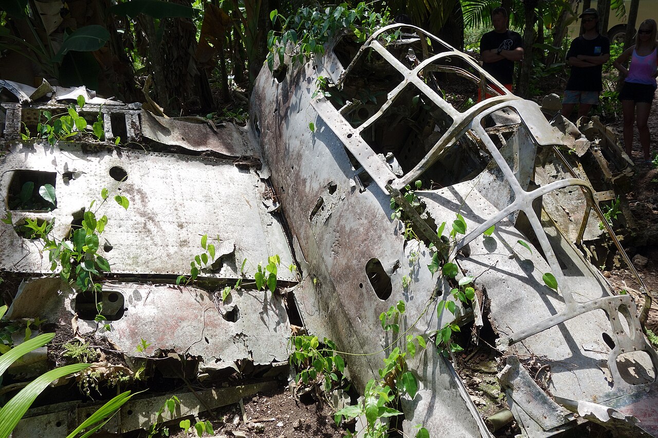
Then go to war, because Peleliu demands it. The Battle of Peleliu (September 15 – November 27, 1944) was among the Pacific war's most savage: the 1st Marine Division, expecting a 4-day fight, took some 73 days against a dug-in Japanese garrison in the Umurbrogol's limestone ridges (Bloody Nose Ridge), at a cost of roughly 1,800 American and nearly 11,000 Japanese dead. The island remains a battlefield park: the Peleliu WWII Memorial Museum (in a former Japanese headquarters), the wrecked Zero in the jungle, Japanese tanks and guns in situ, the 81st Infantry's monuments, Orange Beach itself, and cave systems throughout the ridges — reached by boat from Koror (about an hour) or the state ferry, under Peleliu State's own permit. Angaur, the next island south (phosphate mined by Germans and Japanese; its own 1944 battle), adds wild macaques (descendants of German-era pets) and empty surf beaches.
The thread tying land Palau together is the bai — the traditional chiefs' meeting house, gabled, painted with clan history in pictographs, fronted by stone money paths. Koror's Belau National Museum (the country's museum since 1955) holds a full bai and the culture's record; standing village bais in Airai (the famous Bai ra Rengara Irrai, Palau's oldest, about 200 years old and raised without nails) reward the Babeldaob circuit's southern stop. And above and beneath everything is the conservation state: Palau declared the world's first shark sanctuary in 2009, and the Palau National Marine Sanctuary — in force since January 1, 2020 — closes 80% of the EEZ (an area of about 500,000 km²) to all extraction, which is why the diving is what it is.
Picture the place
Badrulchau at first light: carved stone faces in a row on a grass terrace, the lagoon glittering far below, and not another visitor in the state.
The easily missed detail
Palau's land sights run on state fees and state pride in miniature: each state levies its own small entrance or use fee (waterfall, monoliths, Peleliu's permit), collected at trailheads and offices in cash — carry small USD bills, because the Babeldaob circuit crosses 10 states and their tollbooths of honour. The second detail is the crocodile: Lake Ngardok and Babeldaob's mangrove rivers hold saltwater crocodiles, protected and respected — swimming belongs in the waterfalls' upper pools and the lagoon, never in the mangrove estuaries, however inviting they look.
A practical rhythm
- The Compact Road circuit — A full Babeldaob day: Airai bai, Ngardmau Falls, Badrulchau, Ngerulmud, Lake Ngardok
- Peleliu as its own day — Boat out early, the museum first, then the ridges and Orange Beach
- The museum before the islands — Belau National Museum in Koror on day 1, so the lagoon days carry context
What could complicate the plan
Land Palau has no public transport system to speak of: the Babeldaob circuit needs a rental car (drive on the right, U.S.-style; the Compact Road is excellent, state roads vary) or a hired driver, and distances deceive — 53 miles of loop can eat a day with stops. Peleliu's boat is weather-dependent and its ferry schedule thin; in the wet season the crossing cancels, and the island's tour infrastructure is a handful of operators — book through Koror. State fees, hours and even access (a village bai is a working council house) follow local decision, not a national timetable: Sundays and funeral or chiefly events can quietly close things, and a guide who belongs to the place opens doors that signage does not. The battlefield itself needs care — unexploded ordnance is still found on Peleliu; stay on paths, touch nothing metal in the jungle. And Ngerulmud sets a particular trap for the unbriefed: the capital has almost no services (no hotel strip, few restaurants) — it is a visit, not a base.
What to do next
Rent the car for the Babeldaob day, book Peleliu's boat before you land, and carry $100 in small bills for the states' fees and the trailheads.
Sources
- UNESCO World Heritage Centre / Palau national record — Badrulchau and the Babeldaob terraced landscapes; Airai's bai
- U.S. National Park Service / Peleliu battlefield histories — November 27, 1944; the Umurbrogol ridges; casualty record
- Palau government — the Compact Road (53 miles; completed 2007); the Japan–Palau Friendship Bridge (2002); Ngerulmud capital (2006)
- Palau National Marine Sanctuary / PAN Fund — the sanctuary in force January 1, 2020 (80% of the EEZ no-take); the 2009 shark sanctuary
- Palau Visitors Authority — Ngardmau Waterfall, Lake Ngardok Nature Reserve, Peleliu access and state permits