Colombia country guide When to visit
When is the best time to visit Colombia for Cartagena?
The short answer
February — Cartagena sits in the rainless heart of its dry season, the Andes are in their first dry window at exactly the same time, and the Christmas crowds and prices have gone home.
The answer, with local context
Colombia is the only country in South America with coasts on both the Caribbean and the Pacific, and it straddles the equator closely enough that temperature seasons barely exist: what changes through the year is rain. The real climate dial is altitude. Below about 3,300 feet (1,000 m) lies the tierra caliente, averaging 75–81°F (24–27°C) and hotter; between 3,300 and 6,500 feet the tierra templada averages around 64°F (18°C); and the tierra fría above it averages near 55°F (13°C). A national "best time" is therefore really two questions — when is the coast dry, and when are the mountains dry — and February is the month both answers align.
The mountains run on a double rhythm. IDEAM's 1991–2020 normals give Bogotá, at 8,360 feet (2,547 m) by its airport station, 35 inches (877 mm) of rain a year, peaking in April–May and October–November and bottoming out in January–February and again in July–August, with highs of 65–68°F (19–20°C) in every month. Medellín, at 4,890 feet (1,490 m), is warmer — highs of 81–84°F (27–29°C) — and wetter at 69 inches (1,758 mm), but keeps the same calendar: driest from December to February. The coffee region around Pereira takes 97 inches (2,460 mm), with almost 12 inches (302 mm) in November alone. The one region no month can fix is the Pacific: Quibdó, in the Chocó, averages 321 inches (8,157 mm) of rain a year across some 287 rainy days, and its driest month, February, still delivers 19 inches (487 mm) — more than half of Bogotá's entire year.
Cartagena, the anchor, runs on a single cycle instead: one dry season, December to April, driven by the northeast trade winds, and one long wet season from May to November. IDEAM's normals for the city show January to March bringing less than a fifth of an inch of rain (4 mm) combined, on under one rainy day; the year's 42 inches (1,074 mm) are concentrated in the autumn peak. The coast also dries as you travel east — Santa Marta, the next city along, averages just 22 inches (562 mm) a year. Layer on IDEAM's current outlook and February 2027 strengthens further: the institute's ENSO bulletin records that El Niño brings Colombia significantly less rain and warmer air, and IDEAM confirmed El Niño conditions on June 11, 2026, with probability above 90 percent from September 2026 into early 2027 at moderate or greater intensity — possibly among the strongest events since 1950. A dry-season trip in an El Niño year is the closest thing Colombia offers to a guarantee.
Picture the place
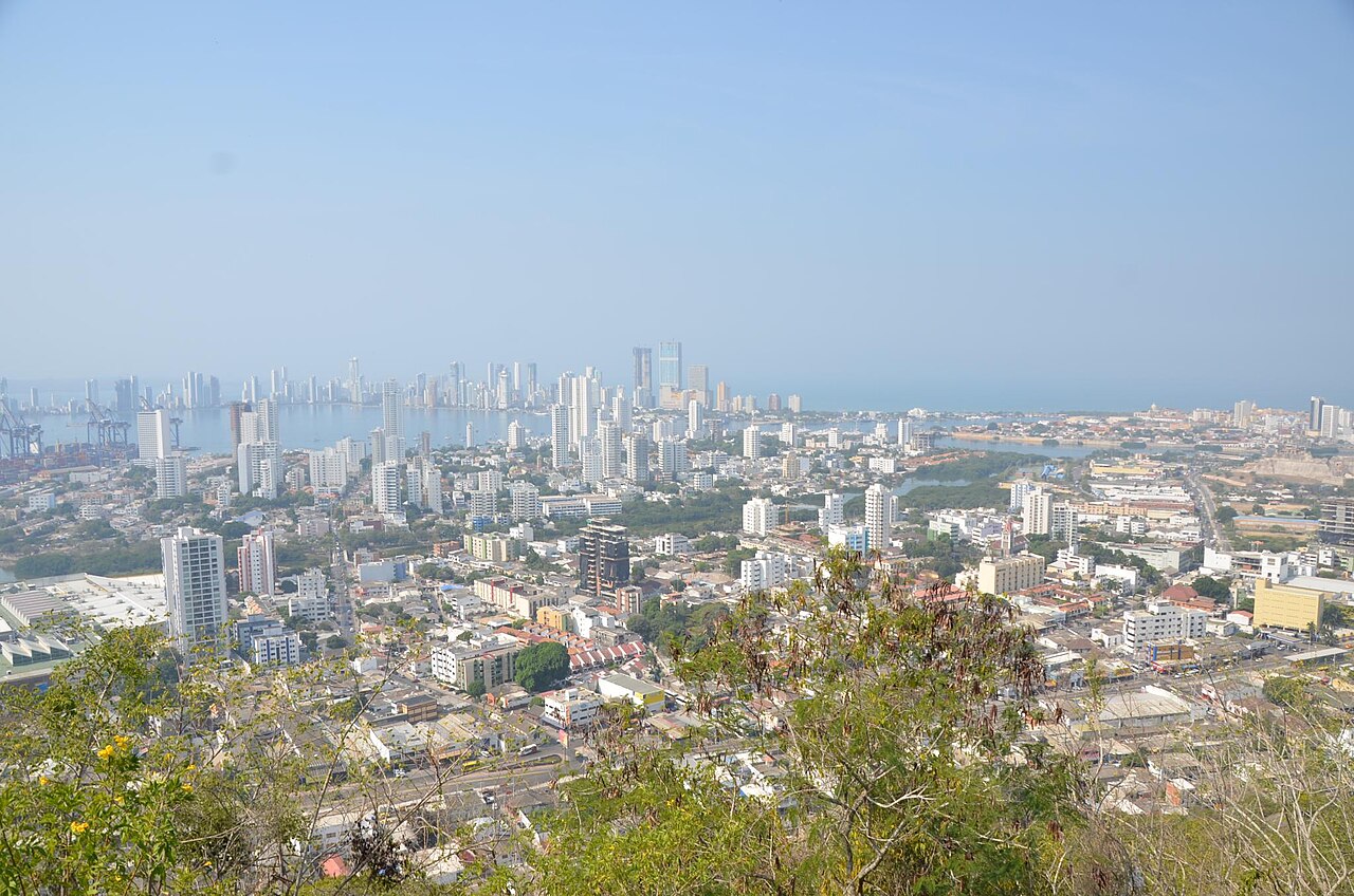
From the hill of La Popa in February the whole geometry is visible at once: the walled old town on its peninsula in the foreground, Bocagrande's white towers behind it, and the Caribbean flat and bright to the horizon — the trade-wind sky of the dry season, with not a rain cloud in the frame.
The easily missed detail
Bogotá has 223 days of precipitation a year on barely 40 inches (1,000 mm) of rain — the capital's rain is a daily drizzle, not a downpour, and it falls in the dry months too. February does not make Bogotá dry; it makes Bogotá as dry as Bogotá gets, which is a different and more useful thing to know when packing for a combined trip.
Cartagena's defenses also carry a designation that changes how you budget the days. UNESCO lists the Port, Fortresses and Group of Monuments of Cartagena under criteria (iv) and (vi), over a core zone of 192.32 hectares inside a zone of influence of 304.09 hectares. The Spanish began the works in 1586 and were still extending them through the 18th century, which is why the city wall, the bastioned harbor of San Matías at the entrance to the Bocagrande pass, the Bocachica forts and the Castillo San Felipe de Barajas on its hill are one property rather than four separate sights. A rainless February day buys the whole system in daylight, and the dry season is the only stretch of the year in which the outer forts are reliably easy to reach by water.
A practical rhythm
- Morning — Cartagena's dry-season mornings belong outdoors: the walls, the forts and the old town streets before the heat peaks, with the trade-wind breeze still moving.
- Midday — In the Andes the pattern inverts: Bogotá and Medellín do their raining in the afternoon even in the dry season, so museums, markets and long lunches are the midday plan, and the viewpoints are for the clear mornings.
- Evening — February evenings on the coast are the year's best: dry, breezy and warm, made for the ramparts at sunset. In Bogotá the same evening needs a jacket — 8,660 feet (2,640 m) does not care that it is "summer."
What could complicate the plan
Two of Colombia's signature experiences refuse February. The Pacific's humpback whales calve from July to October, and Caño Cristales, the five-color river, runs only from early June to late November; a February trip trades both away, and the July–August Andean dry window is the compromise that keeps the river and the whales while accepting a wetter Cartagena. December and early January match February's weather but not its calm: the country's own holiday season fills Cartagena and doubles prices. And El Niño cuts the other way in the mountains — IDEAM's drier, warmer outlook is good news for trails and a stress on Andean water supplies, worth knowing rather than fearing.
What to do next
Book February for the Cartagena-plus-Andes combination, put the coast last so the trip ends in the sun, and read the planning answer in this group for the flight chain — and the vaccination deadline — that the route depends on.
Sources
- IDEAM (Instituto de Hidrología, Meteorología y Estudios Ambientales) — 1991–2020 climate normals as reported to the WMO: Bogotá's 877 mm with peaks in April–May and October–November, Medellín's 1,758 mm, Pereira's 2,460 mm, Quibdó's 8,157 mm over roughly 287 days, and Cartagena's January–March total of 4 mm against a 1,074 mm year
- IDEAM, Seguimiento al ciclo ENOS (ENSO bulletin) — El Niño's drier, warmer effect on Colombia, and the confirmation of El Niño conditions on June 11, 2026, with probability above 90 percent from September 2026 into early 2027
- Encyclopaedia Britannica, Colombia: Climate — the thermal floors from tierra caliente to tierra fría, and Bogotá's average of 57°F (14°C) with 223 days of precipitation a year at 8,660 feet (2,640 m)
- UNESCO World Heritage Centre, Port, Fortresses and Group of Monuments, Cartagena — inscription criteria (iv) and (vi), the 192.32-hectare core zone and 304.09-hectare zone of influence, the 1586 start of the fortifications and their 18th-century extension