Ecuador country guide Places and experiences
What should a first-time traveler see in Ecuador beyond the obvious highlights?
The short answer
Ecuador's second layer is stranger than its first: a crater lake on a volcano loop, the Amazon at its most concentrated in Yasuní, the "Panama" hats actually woven in Cuenca, and a summit that stands farther from the center of the Earth than Everest does.
The answer, with local context
Start with the country's improbable UNESCO density: five properties, and two of them — Quito's historic center and the Galápagos — stood on the very first World Heritage List of twelve in 1978, Quito as property No. 2, cited as the best-preserved and least-altered historic center in Latin America. Beyond those two, Sangay National Park (1983) protects an intact gradient from glacier to rainforest around two of the world's most persistently active volcanoes, and Cuenca's historic center (1999) is the colonial city at walking pace — the real home of the Panama hat, which is woven from toquilla straw in and around Cuenca and Montecristi, its traditional weaving inscribed on UNESCO's Intangible Heritage list. The hat is Ecuador's most successful misattribution: it left for the world through Panama and kept the wrong name.
The geography deals two superlatives. Chimborazo, Ecuador's highest summit at 20,564 feet (6,268 m), is not the tallest mountain above sea level — but because the Earth bulges at the equator, its peak is the farthest point on the planet's surface from its center, roughly 1.2 miles (2 km) farther out than the summit of Everest. And in the Oriente, the Amazon that covers roughly half the national territory with under 5 percent of its people, Yasuní National Park compresses the basin's diversity to a point: a research plot inside the park, censused for decades, holds 787 species of trees and shrubs at least 1 cm thick across just 2 hectares. Ecuador's overall numbers explain the compression — one of only 17 megadiverse countries, it holds about 1,600 bird species, more than the United States and Canada together, in a territory the size of Colorado.
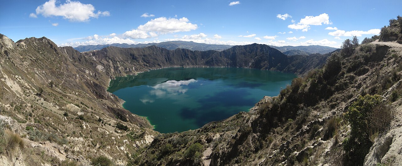
The connective tissue is the highland loop. South of Quito, the Quilotoa crater lake — a turquoise caldera at the end of a multi-day, village-to-village walk through Kichwa communities — anchors the western cordillera's finest trek. Otavalo, north of the capital, holds its great Indigenous market on Saturdays, with smaller editions all week. And Cotopaxi, one of the world's highest active volcanoes and under two hours from Quito, is the accessible giant: a near-perfect cone over páramo grassland, its refuge reachable by road and trail for travelers who are not climbing it.
Picture the place
From Quilotoa's rim the crater lake lies hundreds of feet below in impossible greens and blues, its surface combed by the wind into moving bands of color, the far wall of the caldera striped with ash layers — and the only sound is that wind and, distantly, a farmer's radio from the village behind you.
The easily missed detail
That species count was gathered on one long-term census plot, and the deeper oddity is what surrounds it: the park borders the territory of the Tagaeri and Taromenane, peoples living in voluntary isolation, and a buffer zone exists precisely so that visitors do not approach. The most biodiverse place on Earth is best honoured at a respectful distance — from a lodge on its edges, by canoe, with the forest doing the talking.
A practical rhythm
- Morning — Highland sights are morning appointments: Quilotoa's rim before the afternoon wind whips the lake, Cotopaxi's cone before its daily cloud cap forms, and Otavalo's market as the stalls finish setting up.
- Midday — Cuenca is a midday city: the hat workshops and the river promenades in the long, mild middle of the day, with the museums of the old center either side of lunch.
- Evening — In the Amazon the evening is a program of its own: the night walk from the lodge, frogs and insects at full volume, and the canoe ride back under more stars than the highlands ever show.
What could complicate the plan
Altitude orders everything: Chimborazo's refuge road reaches about 15,750 feet (4,800 m), and Quilotoa's rim tops 12,500 feet (3,800 m) — these are third-week, not first-day, outings. Yasuní requires commitment in the other direction: a flight to Coca, a motorized canoe measured in hours, and a lodge stay of at least three nights to make the journey honest. Sangay, finally, is a name on the list more than a destination — its volcanoes are viewed from the edges, and its interior is expedition country, which is precisely its value on a first trip: knowing it is there.
What to do next
Add one corner, not four: Quilotoa if the legs are willing, Yasuní if the Amazon calls, Cuenca if the trip runs south — and let the planning answer pace them.
Sources
- UNESCO World Heritage Centre — Ecuador's five properties: Quito and the Galápagos on the first list of 1978 (Quito as property No. 2), Sangay National Park (1983), Cuenca (1999) and the Qhapaq Ñan (2014); the traditional weaving of the toquilla straw hat on the Intangible Heritage list
- Smithsonian ForestGEO — 787 species of trees and shrubs of at least 1 cm diameter at breast height recorded across 2 hectares of forest plot in Yasuní National Park
- Ministerio del Ambiente, Agua y Transición Ecológica — Ecuador's megadiverse status, one of 17 countries, with about 1,600 bird species and the Amazon covering roughly half the national territory