Nauru country guide Places and experiences
What should a first-time traveler see in Nauru beyond the obvious highlights?
The short answer
Topside's pinnacle moonscape and the Higher Ground future being built against it, Buada Lagoon's milkfish shore, Command Ridge's Japanese bunkers, Moqua Cave's underground lake, and the Aiwo phosphate cantilevers: Nauru beyond the beach is a single, complete argument about what a nation can spend and what it can mend.
The answer, with local context
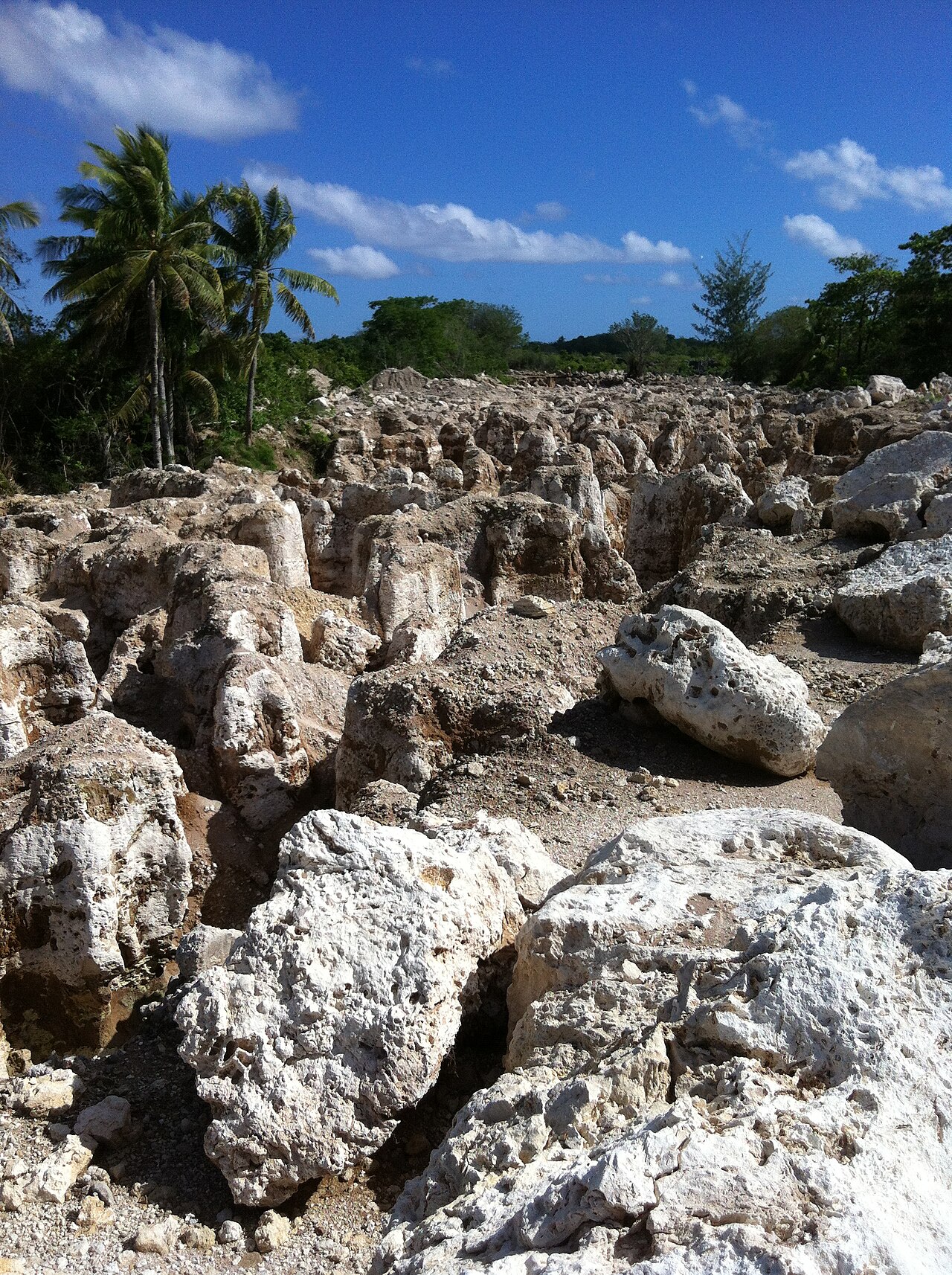
Begin with the interior, because Nauru's story is its center. Topside, the raised plateau covering most of the island's 21 km², was for a century the richest phosphate ground on Earth: discovered by prospector Albert Ellis in 1900, mined from 1906–1907 by the Pacific Phosphate Company, run after World War I by the British Phosphate Commissioners (Britain, Australia and New Zealand), and taken over at independence by Nauru's own corporation, which briefly made this the richest country per head in the world. The phosphate lay between coral limestone pinnacles; when it was dug out, the pinnacles remained — and they still do, across roughly 80% of the island: a white, jagged, silent moonscape of coral towers, now slowly greening at the edges and being worked, plot by plot, by rehabilitation projects (the government's Higher Ground initiative plans levelled, soil-covered land on Topside for homes and farms lifted above the rising sea). It is not scenery in the usual sense; it is the most instructive landscape in the Pacific, and every Nauru visit should spend a morning inside it with a guide who can read it.
The island's soft counterpoint is Buada Lagoon, a landlocked brackish lagoon in a green hollow in the southwest of the plateau — Nauru's only inland water, ringed by homes, bananas and pandanus, and the heir to a distinctive tradition: Nauruans long practised lagoon aquaculture here, catching juvenile milkfish (ibija) at the reef and raising them in Buada and household ponds, a food system now being revived as food-security policy. On the southwest coast near Yaren, Moqua Cave hides an underground freshwater lake (Moqua Well) in the limestone — a torch-lit descent into the island's secret hydrology. The 20th century's other layer sits on Command Ridge, the island's highest point at 71 m: Japanese forces occupied Nauru from 1942 to 1945 (and deported some 1,200 Nauruans to Chuuk, a third of whom never returned), leaving bunkers, a communications post and rusting guns in the scrub — the ridge is both viewpoint and memorial. At Aiwo on the west coast, the phosphate industry's skeleton survives as the great cantilever loading arms that once poured phosphate into ships standing off the reef (the reef has no harbor entrance; ships loaded offshore, and the new Anibare port has only recently given the island a true wharf), while the Nauru Museum in Yaren gathers the culture that predates all of it — the 12 original tribes whose star rides the national flag, the frigatebird tradition, the string-figure and craft heritage of an island that was old when the phosphate was young.
Add the living island and the list completes itself: the Parliament House and government precinct at Yaren (there is no capital city — Yaren is the seat by district), the Civic Centre and Capelle & Partner's emporium at Ewa (the island's department store and social node), the weightlifting gyms of a nation that punches absurdly above its size in Commonwealth sport, and the reef itself — drop-offs, coral pinnacles and game fishing for wahoo and yellowfin that charter boats work from Anibare and Aiwo.
Picture the place
Topside at midday: a field of white coral pinnacles to every horizon, heat shimmering, 1 rehabilitation plot green as a billiard table in the middle distance, and total silence.
The easily missed detail
The pinnacles are a ledger, not just a landscape: each mined field on Topside corresponds to land parcels registered to Nauruan families, whose grandparents received (and famously spent, saved or lost) royalties per load of phosphate dug from their ground — which is why Topside cannot simply be bulldozed into usefulness: every levelling plan negotiates with hundreds of landowning families, and the island's geography of ownership is the hidden map beneath the visible one. The second detail: Buada's milkfish are a climate archive — the pond tradition exists because Nauru's reef fishing fails in rough seasons; the lagoon was insurance, and its revival is policy, not nostalgia.
A practical rhythm
- Topside with a guide — A morning inside the pinnacles, the story told from the ground
- Buada at golden hour — The lagoon circuit on foot when the heat breaks
- The industrial west — Aiwo's cantilevers and the museum paired in 1 slow afternoon
What could complicate the plan
Nauru has almost no formal visitor infrastructure for its own sights: there are no ticketed attractions, few signposts, and Topside access is a matter of local guidance and landowner courtesy — the practical route is a hotel-arranged driver-guide (the Menen and the tourism office can organize), not independent wandering, and the plateau's tracks, heat and pinnacles punish improvisation regardless. Photography carries specific sensitivities: the Regional Processing Centre and its facilities are not a sight, photographing them or approaching their perimeter invites official attention, and drones need clearance in a country where the airport runway and everything else share the same small airspace. Command Ridge and the cave are unlit, uneven and ungated — torches, shoes and a companion are the equipment. And the whole island keeps island hours: government offices, the museum and shops run short days and close on Sundays, and a 3-day visit that loses its Friday to a flight change may lose the museum with it.
What to do next
Ask the hotel, on arrival day, to arrange the Topside-and-Buada circuit with a local guide — it is the island's essential half-day and it cannot be self-organized well.
Sources
- Nauru government and rehabilitation programme materials — Topside mining history (phosphate discovered 1900, mining from 1906–1907), about 80% of the island mined, the Higher Ground initiative
- Historical record — the British Phosphate Commissioners era; the Japanese occupation 1942–1945 and the Chuuk deportations; Command Ridge (71 m)
- Nauru Tourism / Nauru Museum — Buada Lagoon and the ibija milkfish tradition; Moqua Cave; the 12 tribes
- ADB / Government of Nauru — the Anibare port project and the Aiwo cantilever loading history