Patagonia / Argentina Things to do
What are the most worthwhile things to do in Patagonia on a first visit?
The short answer
Build the first visit on four anchors, one per sub-region: the Perito Moreno Glacier's boardwalks in the south, the Fitz Roy trails from El Chaltén in the northern ice field, the penguins of Punta Tombo on the Atlantic coast, and Ushuaia's Beagle Channel at the end of the road.
The answer, with local context
In the far south, Los Glaciares National Park — created in 1937, inscribed by UNESCO in 1981, and at 2,807 square miles (7,269 km²) Argentina's largest national park — protects the eastern slope of the Southern Patagonian Ice Field, at 5,213 square miles (13,500 km²) the third-largest mass of ice on Earth after Antarctica and Greenland, feeding 47 major glaciers. Its celebrity is the Perito Moreno, reached from El Calafate, 50 miles (80 km) away: a river of ice 19 miles (30 km) long whose front, 3 miles (5 km) wide, rises 197 to 243 feet (60–74 m) above Lago Argentino and advances about 6.5 feet (2 m) a day, so that the boardwalk system — some 3 miles (4–5.5 km) of walkways standing about 984 feet (300 m) from the face — is a theater built for a performance that never stops: the crack, the pause, the calving wall of ice. The park now charges for entry: since June 1, 2026, under APN resolutions, foreign visitors pay ARS 50,000 a day, a rate that covers the boardwalks, with boat trips and ice treks booked separately on top, and 3- and 7-day Flexipasses (ARS 100,000 and ARS 175,500) covering the El Chaltén trails as well.
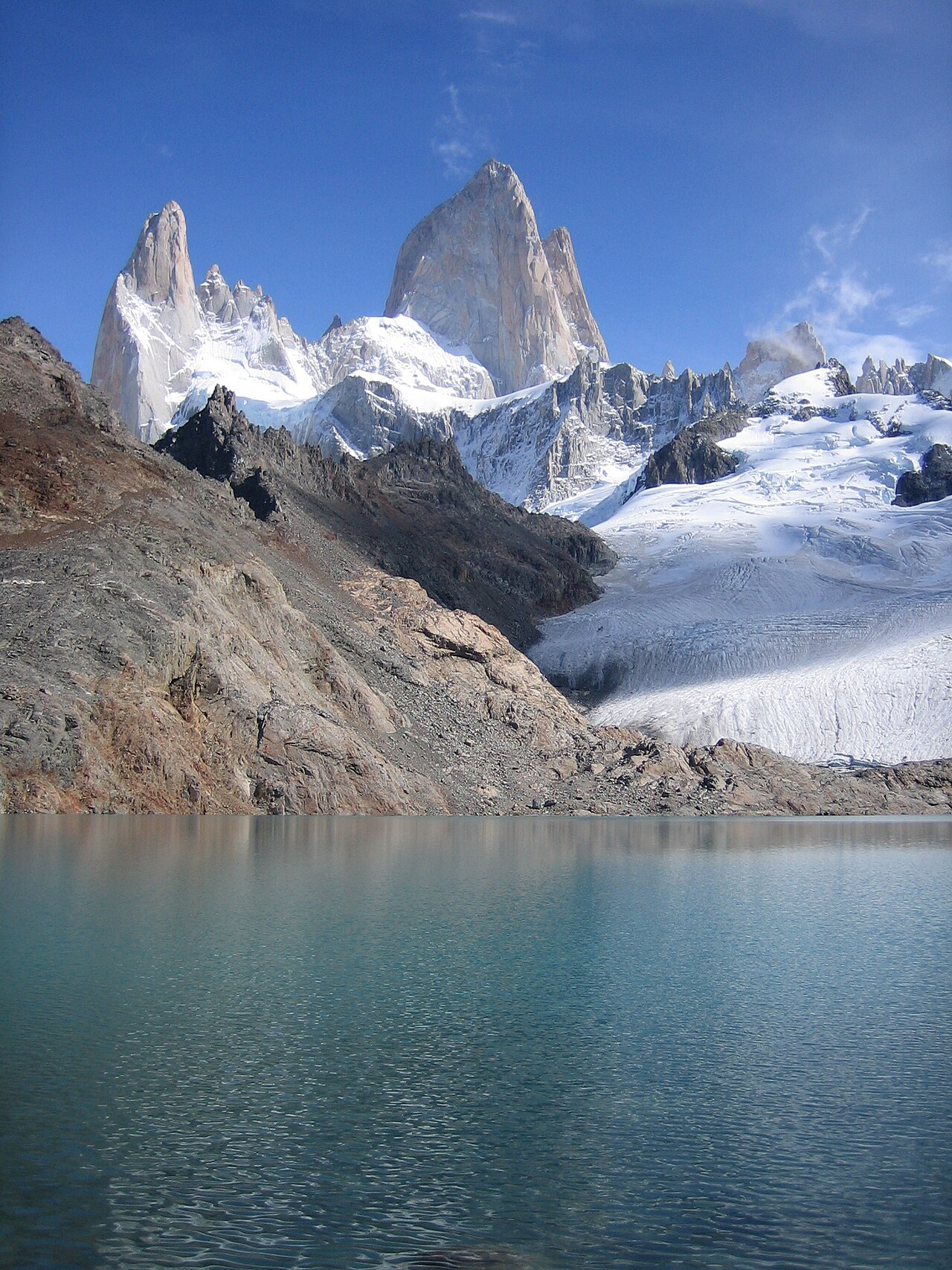
El Chaltén, 137 miles (220 km) and three hours north, is the park's other face: a town founded only in 1985, planted to assert Argentina's claim in a border dispute with Chile, now the trailhead capital where the hikes begin at the end of the main street. Fitz Roy rises to 11,171 feet (3,405 m) — named for the Beagle's captain, called Chaltén, "smoking mountain," by the Tehuelche for the cloud that streams from its summit — and the Laguna de los Tres trail, 15.5 miles (25 km) round trip with 2,600–2,950 feet (800–900 m) of climbing, ends at the glacial lake at its foot. The Atlantic coast answers with different wildlife: Punta Tombo's reserve holds the largest continental colony of Magellanic penguins, hundreds of thousands of birds in the breeding season, walked among on marked paths; Península Valdés, detailed in this library's Argentina answer, adds the right whales of winter and spring. And the road itself ends at Ushuaia, the world's southernmost city, where the Beagle Channel cruises sail past sea lion and cormorant colonies, Tierra del Fuego National Park protects the coast where the Andes meet the sea, and from late October to late March the Antarctic expedition ships load for the ice.
Picture the place
From the lowest boardwalk at Perito Moreno the glacier fills the world: a fractured wall of blue and white ice three miles wide, creaking and ticking in the sun, the lake below milky turquoise with its flour — and every few minutes a crack like artillery, a white plume, and a new iceberg rolling slowly in the wash while the whole walkway applauds.
The easily missed detail
The Perito Moreno's fame rested on its stability — for decades it was the rare glacier holding its position while its neighbors retreated — and a study published in August 2025 in Communications Earth & Environment revised the story: broadly stable from 2000 to 2019, retreating less than 328 feet (100 m), it has since pulled back more than 2,600 feet (800 m) in places, with thinning at the front accelerating from about 1.1 feet (0.34 m) a year to 18 feet (5.5 m). The boardwalks now overlook a glacier in the act of changing its mind — go while the geometry you read about is still the geometry there.
A practical rhythm
- Morning — Perito Moreno in the morning, when the light strikes the front obliquely and the day buses from El Calafate have not yet arrived; the calving is most audible in the still air.
- Midday — The steppe crossings are the midday hours: the drives between El Calafate, El Chaltén and the coast are long, straight and hypnotic, with guanacos and rheas as the roadside cast — schedule them as part of the show, not as dead time.
- Evening — El Chaltén's evenings are the hiker's ritual: the weather boards checked in the cafés, the Fitz Roy silhouette taking the last light, and tomorrow's route chosen by the wind forecast rather than by hope.
What could complicate the plan
Distance is the region's tax: Patagonia's four anchors span some 1,200 miles (1,900 km) of north–south travel, and a first visit that attempts all of them in a week spends it in buses. The fee system has also changed under travelers' feet — the El Chaltén portals now take the park pass online only, no cash — and residents of El Calafate and El Chaltén enter free, so the prices quoted by older guides and blogs are a season out of date. Finally, the famous rupture of the Perito Moreno's ice bridge — the arch that forms and collapses in Lago Argentino — is an event of years, not weeks: the last confirmed collapse was on December 28, 2019, and no itinerary should be built around witnessing one.
What to do next
Choose two anchors, not four: Perito Moreno with El Chaltén for the ice-and-granite trip, or Punta Tombo with Ushuaia for the sea — and read the hiking answer before promising yourself any summit.
Sources
- UNESCO World Heritage Centre — Los Glaciares National Park, created in 1937 and inscribed in 1981, protecting the Southern Patagonian Ice Field and its 47 major glaciers across 2,807 square miles (7,269 km²)
- Administración de Parques Nacionales (APN) — Los Glaciares entry rates effective June 1, 2026 (Resolutions 132/2026 and 157/2026): ARS 50,000 per day for foreign visitors, covering the Perito Moreno boardwalks; Flexipasses of ARS 100,000 (3 days) and ARS 175,500 (7 days) also covering the El Chaltén portals, which accept online payment only
- Communications Earth & Environment (August 2025) — the Perito Moreno study: stable from 2000 to 2019, retreat of more than 2,600 feet (800 m) in places since 2019, and front thinning accelerating from 1.1 to 18 feet (0.34 to 5.5 m) a year
- Gobierno del Chubut — Punta Tombo, the largest continental Magellanic penguin colony, in its provincial protected area