Peru country guide Places and experiences
What should a first-time traveler see in Peru beyond the obvious highlights?
The short answer
Peru holds 13 UNESCO World Heritage properties, and the deeper list runs north and back in time: Caral, the oldest city in the Americas at 5,000 years; Chan Chan, the world's largest adobe city; Kuélap, the cloud-forest fortress of the Chachapoyas; Colca Canyon and its condors; and Manu, the full descent from Andes to Amazon in a single park.
The answer, with local context
Start at the beginning, which predates the Inca by three and a half millennia. In the Supe Valley, 113 miles (182 km) north of Lima, the Sacred City of Caral-Supe — UNESCO-listed in 2009 — was already building six great platform mounds and sunken circular plazas around 3000 BC, contemporary with the pyramids of Egypt and the cities of Sumer, without pottery, writing or war: the oldest known urban civilization in the Americas, set in desert hills an easy day trip from the capital yet visited by a trickle. The north coast continues the story at Trujillo, where the Chimú capital of Chan Chan spreads across 7.7 square miles (20 km²) of adobe — nine walled citadels, each a king's palace turned mausoleum — inscribed in 1986 and on UNESCO's Danger List from the same year, its reliefs of fish and seabirds slowly eroding under El Niño rains. The newest addition, the Chankillo Archaeoastronomical Complex, inscribed in 2021, adds the desert's own astronomy: thirteen towers on a ridge that track the sun's annual path.
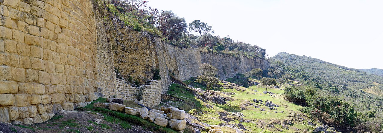
In the northern mountains, the Chachapoyas — the "warriors of the clouds" — built Kuélap between roughly 900 and 1100 AD on a ridge at 9,842 feet (3,000 m): outer walls rising up to 66 feet (20 m) enclosing more than 400 circular stone houses. Largely ignored until Peru opened its first cable car to reach it in 2017, Kuélap delivers the Machu Picchu emotional register — a citadel in cloud forest above a river gorge — at a small fraction of the footfall. The south holds the canyon country beyond Arequipa, whose sillar-stone historic center is itself UNESCO-listed (2000): the Colca Canyon cuts more than 13,000 feet (4,000 m) from rim to river at its deepest, about twice the Grand Canyon, and at the Cruz del Cóndor lookout the Andean condors, wingspans reaching 10 feet (3.2 m), ride the morning thermals within yards of the rail. Arequipa's Santa Catalina Monastery, founded in 1580, is a walled city of colored streets that housed up to 200 Dominican nuns in near-total seclusion for almost four centuries.
Nature's version of the list runs on the same scale. Manu National Park protects over 4.2 million acres (1.7 million hectares) in a single sweep from 13,000 feet (4,000 m) of Andean grassland down to lowland rainforest at 1,150 feet (350 m) — one of the most biodiverse protected areas on Earth, in a country counting more than 1,800 bird species. Huascarán National Park guards the Cordillera Blanca and Peru's highest summit, 22,205 feet (6,768 m). The through-line of the deeper Peru is chronological: the highlights show you the empire's final century; everything above shows you the 5,000 years that made it possible.
Picture the place
At Kuélap the cable car cabin crosses a sea of cloud to a wall of fitted stone 66 feet high running the length of a mountaintop, and inside the gate the streets are round — four hundred stone circles in the mist, their conical roofs long gone, orchids in the wall joints, and no crowd: the fortress hears its own weather.
The easily missed detail
Caral upends the usual museum logic of civilization: its builders raised monumental pyramids at the same era as Egypt's, yet the site produced no weapons, no fortifications and no evidence of warfare — its excavated treasures are flutes made from condor bone and a knotted-string quipu, suggesting a society organized around trade, agriculture and music. Standing in its sunken plaza, you are in the Americas' first city, and the loudest thing about it is the wind.
A practical rhythm
- Morning — Mornings belong to the lookouts and the desert: condors fly on the first thermals at Cruz del Cóndor, and Chan Chan's adobe reliefs read best — and burn least — before the coastal sun tops the walls.
- Midday — Midday is museum and monastery time: Santa Catalina's shaded streets in Arequipa, and Trujillo's museums holding the Moche and Chimú gold that the open sites surrendered long ago.
- Evening — Evenings go to the small cities: Arequipa's sillar facades turn rose at sunset under El Misti's cone, and Chachapoyas town, the base for Kuélap, dines early and sleeps earlier.
What could complicate the plan
Geography taxes every addition: Peru's deeper list is spread across a country of 496,225 square miles (1,285,216 km²), and Caral, Chan Chan and Kuélap pull north while Colca and Manu pull south — one trip can honor one direction. Chan Chan is actively eroding, and its custodians close the most fragile reliefs; Manu's protected zone is reachable only on multi-day guided expeditions from Cusco, with no independent access; and Kuélap's cable car closes for maintenance periods that vary by year — check its operating calendar before routing a trip around it.
What to do next
Choose a north or a south: Lima–Caral–Trujillo–Kuélap for the archaeologists' Peru, or Arequipa–Colca with a Manu expedition for the natural one — and give whichever you choose the days the highlights saved you.
Sources
- UNESCO World Heritage Centre — Peru's 13 properties (nine cultural, two natural, two mixed): Caral-Supe inscribed 2009 as the Americas' oldest urban center; Chan Chan 1986 and simultaneously placed on the List of World Heritage in Danger; Arequipa 2000; Chankillo 2021
- Ministerio de Cultura, Peru — Kuélap's Chachapoyas fortress: walls up to 66 feet (20 m), more than 400 circular buildings, occupied from about 900 to 1100 AD, reached by Peru's first cable car, opened in 2017
- SERNANP (Servicio Nacional de Áreas Naturales Protegidas) — Manu National Park's 4.2 million acres (1.7 million hectares) descending from 13,000 feet (4,000 m) to 1,150 feet (350 m); Huascarán and Peru's highest summit at 22,205 feet (6,768 m)